1. Introduction
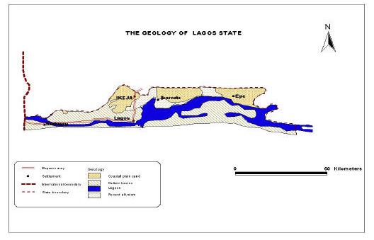
IS is any computerized tools that can be used for analysing, managing, editing, Manipulating, retrieving, converting, storing and output of a Geographic data which are spatially georeferenced in the air. It has been found to be a veritable and effective tool in the management of database for groundwater pollution assessment. Surface resistivity methods have been employed successfully for detecting and mapping ground water contamination under a variety of conditions. The method is based on the fact that formation resistivity depends on the conductivity of the pore fluid as well as the properties of the porous medium. Integrating the GIS and resistivity techniques has been proved to be an efficient tool in groundwater pollution studies. Under favourable conditions, contrasts in resistivity may be attributed to mineralized ground water with a higher than normal specific conductance originating at a contamination source. Success has been reported in tracing water from landfills (Cartwright and McComas, 1968;Cartwright and Sherman, 1972;Stollar and Roux, 1975), sewage treatment effluent (Fink and Aulenbach, 1974), salt piles (Fried and Ungemach, 1971).The lithologies of the study area consist of the recent sediment, coastal plain sand, ewekoro formation, and Abeokuta formation which directly overlie the basement complex. Groundwater is a major source of water supply in Lagos state despite the provision of potable water through the state government micro water works to the people of Ikeja, the populace still depends on wells (shallow and deep) for their domestic water supply. The suitability of groundwater for drinking especially in areas close to the landfill in the study area has continued to raise a source of concern due to the possibility of contamination which pose a major environmental and health concern. The study area is located within the western part of Nigeria, a zone of coastal creek and Lagoon (Elueze, et al, 2004). The area is also developed by barrier beaches associated with sand deposits (Ogbe F.G.A, 1992).The study area (Ikeja) is geologically underlain by sediments of Dahomey Basin (Geology of Nigeria).The lithologies of this study area are grouped into Recent Sediments, Coastal Plain Sands, Ilaro Formation, Ewekoro formation and Abeokuta formation, which directly overlies the basement. Geologically, the study area is within the coastal plain sand (Figure 3).
2. Spatial Querry Analysis
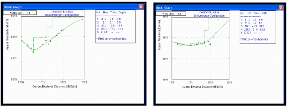
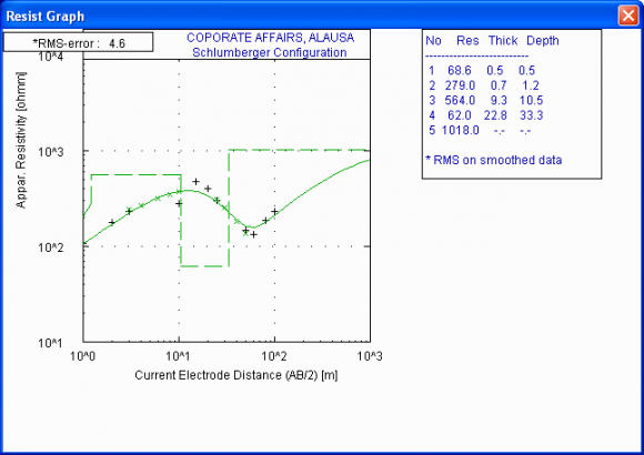
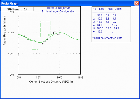
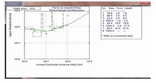
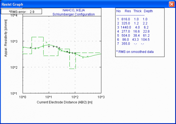
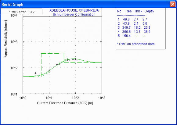
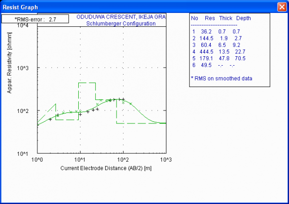
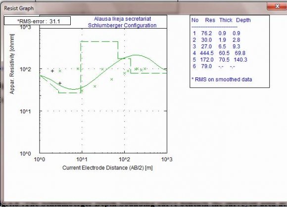
Spatial data query were performed using the data generated in terms of resistivity, depth, Lithology in ArcGIS and the following resulted as represented from figure 13 to 17 the curves and information from a borehole log and published resistivity data (Telford et al; 1990), the equivalent geologic units has been delineated. The aquifer units are Coarse Sand, Sandstone, Fine Sand and Gravelly Sand. The second layer in VES 1 represents Clay with resistivity value of 18 ohm-m and thickness of 3.2m considered as poor quality fresh water which is highly polluted and the fourth layer is characterized with sand having resistivity value of 290 ohm-m and layer thickness of 15.3m envisaged as Good quality fresh water zone. The fifth geoelectric layer is coarse sand with resistivity of 806 ohm-m considered as Good quality fresh water. The third layer in VES 4 is clay with resistivity value of 15.6 ohm-m and thickness of 4.5m considered as poor quality fresh water. This layer has been highly polluted. The fifth layer in this VES is Sand with a resistivity of 365ohm-m and a thickness of 23.0m considered as a good aquifer with Good quality fresh water. The third layer in VES 5 is clay having a low resistivity of 24 ohm-m and a thickness of 3.5 m. This layer is a polluted region considered having poor quality fresh water. The second layer and the third layer of VES 9 delineate sand with resistivity ranging from 27.0 ohmm to 30.0 ohm-m. These layers are highly polluted due to the leachate effect from the Olososun landfill around Oregun, Ikeja.Lagos State, Nigeria.
3. VI. Conclusion and Recommendations
From the result of the electrical resistivity sounding carried out in the study area, the study has shown that Geographic Information System (GIS) and Geophysics are very useful in the assessment of the groundwater pollution. GIS Application as a database tool has also been very important and highly useful when integrated with geophysical methods. Most of the surface aquifers that are very nearer to the Oloshosun landfill have been polluted by the adjoining leachate of the Landfill thereby posing a threat to the groundwater of the area. Dwellers very nearer to the oloshosun Landfills are in a great danger because of the fact that most of their surface aquifer has been polluted by the adjoining leachate of the Landfill thereby posing a threat to the groundwater Geology of the area. This effect was noticed in VES 9 and this occurs between the depths of 2.8m to about 9.3m. Between these depths, the possibility of the shallow aquifer to be polluted is very high. The surface aquifer has also been polluted in VES 5 to the depth of about 6.0m.It is recommended hydrogeologically that in VES 2, 3,6,7,8 and 10, a deep borehole could be drilled to provide good sources of water, especially in VES 2, and also a deeper borehole can be drilled in VES 9 to a depth of 220 to 250m. A further mapping of the fresh water and salt water interface in the coastal aquifers should be carried out concurrently to further delineate possible sub-surface pollution plume to better understand the groundwater conditions of Ikeja and its environs. Other methods that could provide solution to pollution problems of the study area include geochemical analysis of boreholes, wells, and geophysical well logging of the existing boreholes.
VII.