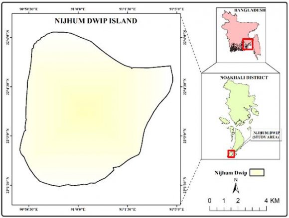
1. Introduction
oastline and coastal areas of Bangladesh are neither uniform nor static, but also dynamic (Brammer, 2014) due to shifting through the short and long-term processes (Schwartz, 2006). The Coastal zone covers 32% of Bangladesh involving Jessore, Narail, Gopalganj, Shariatpur, Chandpur, Satkhira, Khulna, Bagerhat, Pirozpur, Jhalakati, Barguna, Barisal, Patuakhali, Bhola, Lakshmipur, Noakhali, Feni, Chittagong, and Cox's Bazar. Estuaries, islands, accreted land, beaches, peninsula, rural settlements, urban and industrial areas, ports, etc. are usual features (Iftekhar, 2006). Around 35 million people representing 29% of the total inhabitants live in the coastal zone (Uddin & Kaudstaal, 2003). Except for Chittagong-Cox's Bazar, all parts of the coastal zone are plain land with extensive river networks and accreted land (Sarwar, 2005). The morphology of the coastal region in Bangladesh is quite unstable due to simultaneous erosion and accretion, variation of river flow, sediment load (Shibly and Takewaka, 2012). Besides, strong tidal currents, vigorous wave action (Sarwar & Woodroffe, 2013) along the coast and physical environments, human interventions (Hassan et al., 2017) are other crucial reasons for the changes. Identically, mangrove forest is decreasing while cultivable lands and settlement are growing over the year . However, rapid geomorphological changes are going on in the Meghna estuary (Brammer, 2014), also Nijhum Dwip is one of the islands in the Meghna estuary of the Bay of Bengal where changes are instantaneous. Along with, land use patterns are changing to meet the demand of society, which may be a concerning issue in the perspective of putting pressure on the environment and deteriorating newly formed land. Usually, land use changes indicating the land utilization by people (Anderson et al., 1976;Di Gregorio and Jansen, 1997;Lillesand and Kiefer, 2002) when change detection is practicing to identify the spatial changes of the surface of the earth at diverse temporal ranges (Singh, 1989) Tanim et al., 2013). As study concerning Spatio-temporal changes on land cover and coastline of the Nijhum Dwip is less frequent, the present investigation is broadly an attempt to detect the land cover changes and evaluate the lateral shifting of coastline from 1980 to 2018 of Nijhum Dwip, Bangladesh. Therefore, coastal change detection is critical in coastal zone application and is significant for future coastal dynamic studies (Lu et.al. 2004). This research provides an integrated spatial analysis using
2. MATERIALS AND METHODS
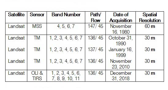
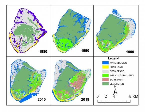
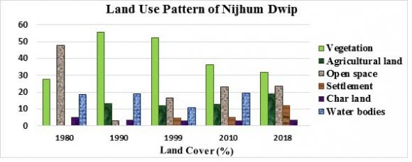
This study uses multi-temporal Landsat satellite images and data to analyze the spatial dynamics of Nijhum Dwip from 1980 to 2018 (Table 1). 2 and 3), where agricultural land was increasing continuously after 1990.
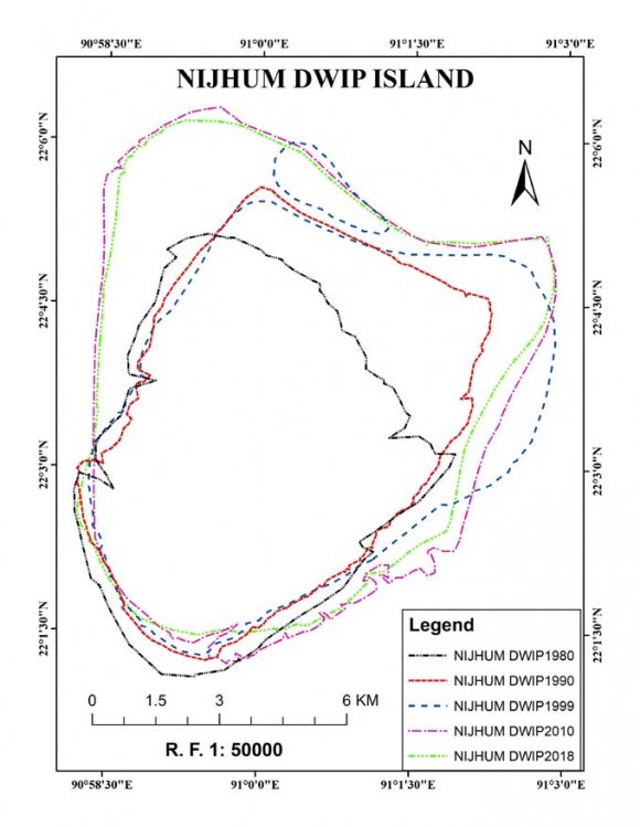
However, inland water bodies in the study area are a fluctuating phenomenon because of their location in the estuary which is always active, unpredictable, and due to erosion-accretion amount variation. Maximum inland water bodies were 9.76 km2 (19.36%) in 2010 and 4.68 km2 (9.79%) was minimum in 2018. Along with, 5.45 km2 (18.83%), 6.42 km2 (19.09%), 4.40 km2 (10.97%) area were as water body in 1980, 1990 and 1999 respectively. Likewise, char lands were another changeable feature because of varied fluvial and marine geomorphological agents and processes. Accordingly, 1.68 km2 (5.80%), 1.15 km2 (3.42%), 1.24 km2 (3.09%), 1.57 km2 (3.11%) and 1.61 km2 (3.37%) was as char lands along the riverside in 1980, 1990, 1999, 2010 and 2018. On the other hand, 13.78 km2 (47.62%), 2.87 km2 (3.06%), 6.72 km2 (16.76%), 11.61 km2 (23.03%), 11.31 km2 (23.67%) identified as open space on the land surface in 1980, 1990, 1999, 2010 and 2018 consequently. However, in the analysis open space is showing a frequent change than the other land-use types. Furthermore, with time this landmass turned into a lucrative place for seasonal migrants and then permanent settlement. Developed char lands or islands like Burir char, Sukh char, Sonadia, etc. might be another choice but people are moving to the Nijhum Dwip rather than shifting to the mainland despite facing numerous disasters like cyclones, riverbank erosion, flood, storm surge, sea-level rise, salinity intrusion, etc. considering livelihood opportunities, low price of land and have no other options (Kumar and Luna, 2018). Although, primarily the island was just an afresh settled sediment deposited landmass in the Meghna estuary without human population. Thus, there was no settlement in the years 1980 and 1990 since the land was less suitable for settlement and agriculture than older land. Afterward, 1.92 km2, 2.56 km2, and 5.72 km2 area occupied and which were 4.79%, 5.09%, and 11.97% out of the total land surface in 1999, 2010, and 2018 for settlement on the mainland (Figure 2 and 3). The abovementioned findings of the study area indicating that more population settlement, expansion of infrastructure each year on the island, and more land utilization for agricultural practice, farming, etc. are the main reasons for open space and vegetation cover reduction. that land gain might exceed land loss resulting from the slow rate of erosion (Figures 4 and 5). After that, a projection from 2028 to 2068 produced based on existing total area and rate of change per year data to evaluate the pattern of transformation and increase of land surface forecasted here because the overall accretion rate is over than the rate of erosion in Nijhum Dwip (Figure 4). However, the direction of the accretion and erosion on the island varies from year to year and it is a lively process. From 1980 to 1990, the coastline changed by raising and decreasing towards the northeast through deposition and erosion. Later, from 1990 to 1999, the shoreline extended westwards whereas from 1999 to 2010 shoreline shifted to the northwest by sediment deposits. Then again within the period of 2010 to 2018, the overall reduction of the landmass observed on the southwest and southeast edge. Hence, it is visible that the upper north part of Nijhum Dwip is shifting by enlargement of landmass towards the north, north-east and north-west direction than the southern part which is mostly sediment wearing away prone side of the island (Figure 5). It is apparent that land utilization is usually direct by the population growth, development activities putting pressure, and filling of low-lying areas, and clearing of vegetation may result from erosion of topsoil and a large range of negative environmental impacts. However, expansion and reduction of landform largely rely on land gaining and losing with the influence of coastal geomorphological agents and processes. Sustainable