1. Introduction he VLF-EM technique was developed in the 1960s
with the use of the transmitted signals of the already established powerful radio communication stations (in the 10-30 kHz band). The transmitters of these stations generate primary fields with horizontal magnetic components ( y H ), and vertical electric component ( z E ). Both components are perpendicular to the direction of propagation (X). At great distance, their wave front is considered uniform and plane. It is known that the induction caused by the primary magnetic field in a homogenous earth modifies the y H component and creates a horizontal electric component x E , and when a subsurface conductor is encountered, a secondary magnetic field will be generated (Mahemedet al., 1998).In recent times, the VLF EM method has been applied successfully to map the resistivity contrast at boundaries of fractured zones having a high degree of connectivity (George et al., 2013). Also VLF method yields a higher depth of penetration in hard rock areas because of their high resistivity (McNeill and Labson, 1991). VLF method is capable of delineating fractures in lateral direction effectively compared to resistivity sounding (Sharma and Baranwal, 2005), characterize aquifer structures in a complex environment (Ozeginet al., 2012), underground water contamination by solid waste (Deborah and Ayobami, 2013) and examination of the fault pattern of industrial estate (Theophilus and Lukman, 2012).
The Very Low Frequency Electromagnetic (VLF -EM) method has found useful application in groundwater investigation in basement terrain, most especially as a reconnaissance tool (Amadi and Nurudeen, 1990;Olorunfemi et. al., 1995). It is an accepted fact that most of the ground VLF-EM anomalies are caused by the galvanic effect (McNeil, 1985) where the influence of frequency may be neglected (Guerin et al., 1994). This method of geophysical prospecting was primarily developed for the delineation of sheet -like metallic conductors, which are often concentrated within fault and fracture zones which are known to be good groundwater aquifers, particularly when the fracture frequency is high (Olorunfemi et. al., 1995). The technique may be applied indirectly to the location of sites with appreciably thick overburden to the mapping of geological structures such as fault and fracture zones that are favourable to groundwater accumulation (McNeil, 1980;Palacky et. al., 1981;Adiat et. al., 2009).
The mapping of fracture zone which is a break in crystalline basement rock due to tectonic forces or intrusion of magmatic bodies is important for civil engineering and hydrogeological applications. In civil engineering, it helps to locate the safest depth to lay the foundation of buildings. This study was driven by the desire to investigate water bearing fracture zones in the area under investigation using very low frequency (VLF) electromagnetic method. Most boreholes drilled in the past in the area are unproductive and due to this failure, it is therefore necessary to use an appropriate geophysical method to locate the fracture zones. This became important as the inhabitants of the study area depend solely on streams, lakes and groundwater for their domestic needs and otherwise.
2. II.
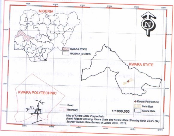
The Study Area Kwara State in its entirety is located in the North-Central part of Nigeria. It lies between the Longitude 3 0 and 6 0 E and Latitude 8 0 and 10 0 N respectively (Fig. 1). It covers an area of over 32,500 square kilometer and bounded by an international boundary with Benin Republic in the West, in the North by Niger, in the East by Kogi and to the south by Oyo, Ekiti and Osun. The progressive population growth in Ilorin, the nearest major town to the study area, has led to severe shortage of portable drinking water for the area which poses a great challenge to both the citizens and the government. It is therefore obvious that the demand for reliable and consistent water supply is high. Certainly the use of water is beyond mere domestic as virtually all the industries, companies and governmental establishments are in dare need of water. Such high demand can only be achieved through viable boreholes. The drilling of viable boreholes can be obtained by carrying out adequate geophysical studies to empirically ascertain areas or sites where long term steady supply can be achieved.
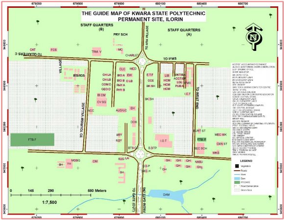
Furthermore, rapid industrialization recently witnessed by the Ilorin metropolis has resulted in population increase and has led to the urbanization of satellite villages and settlements of which the ancient Eleko, Kwara Poly. (Permanent site), Ara and Akuo settlements, all of which fall in the study area. The people of these settlements depend solely on surface water from streams and hand dug wells for their domestic use. However, these sources of water are highly vulnerable to pollution thereby making the people to be susceptible to water borne diseases. Moreover, fast increase population growth of this region occasioned by the influx of people from nearly congested city of Ilorin, coupled with the location of government institutions such as Kwara State Polytechnic and University of Ilorin Teaching Hospital has also made these sources of water inadequate for its dwellers, and the need for good quality and readily available portable groundwater in this area forms the basis for this research.
3. III.
4. Materials and Methods
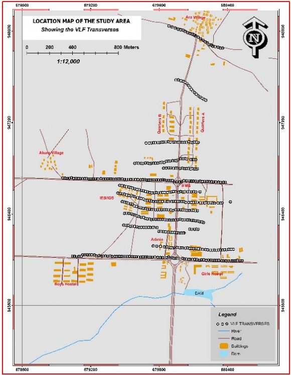
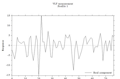
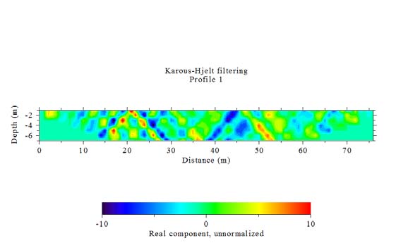
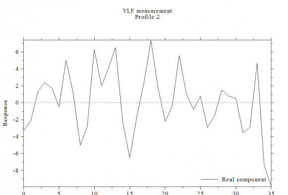
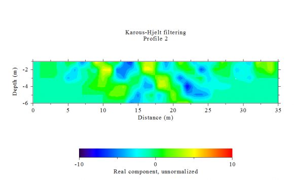
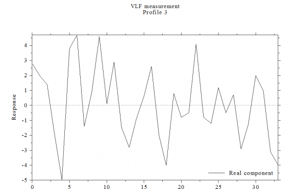
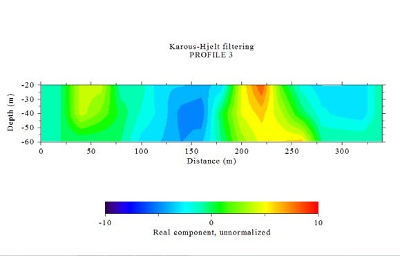
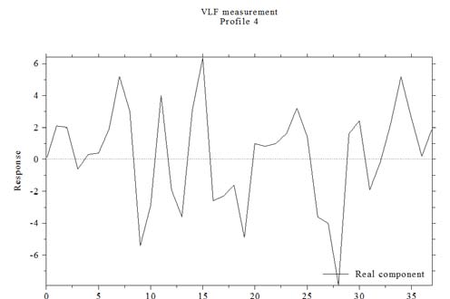
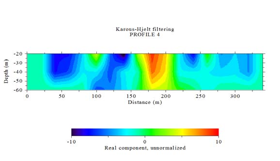
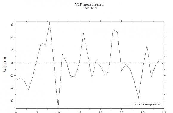
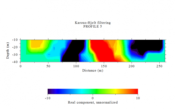
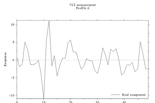
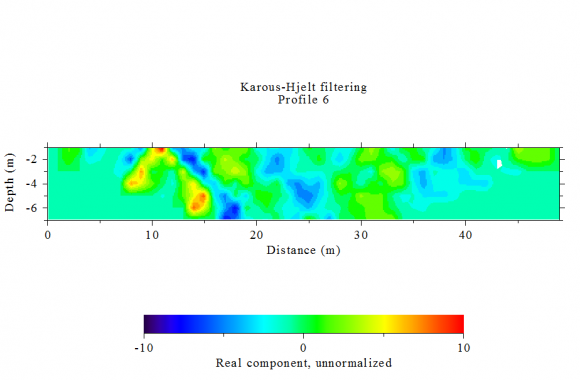
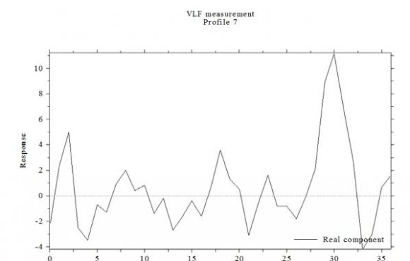
The ABEM WADI VLF-EM Instrument used to measure the EM response is a portable instrument which measures the electrical properties of the subsurface, using EM induction as detailed in McNeil (1980a). In this work, thirteen EM profiles were made using a 20m coil spacing, with an expected maximum depth of investigation of about 15m for the horizontal dipole (HD) mode (McNeil, 1983). The EM data were collected at 20m interval along thirteen profiles (Fig. 3) with lengths ranging from 300 to 1700m. The VLF-EM data were presented as profiles figures by plotting raw real (quadrature) measured on the field and the filtered real while their corresponding Karous-Hiljet (K-H) pseudo sections are shown in Figures respectively. The The VLF WADI instrument displays the filtered real anomaly on the screen, and this anomaly can be roughly interpreted on site. This feature of the instrument is used to select sounding locations for resistivity surveys. For further detailed information of the subsurface, the measured real anomalies were rediscretized at 1 m interval and filtered using the approach of Karous and Hjelt (1983). This process yields pseudo-section of relative current density variation with depth. A higher value of relative current density corresponds to conductive subsurface structures.
IV.
5. Results and Discussions
It is observed that apparent current density cross-sections using real and imaginary anomalies show almost similar features. Therefore, for simplicity only the real component results are presented below (Fig. 4
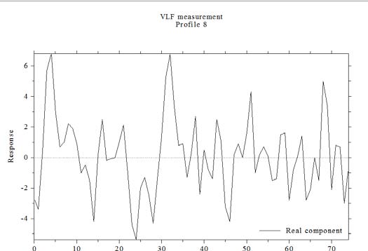
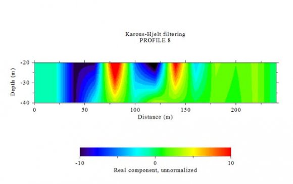
At location VLF 06 with traverse oriented in the E-W direction, a well-fractured zone with positive Fraser filter was identified (Fig 9a). It is located at a horizontal distance between 11-13m, along the profile at depth of between 2-6m. Similar was the case at location VLF 07 with a prominent fracture zone located at a horizontal distance between 28-34m (Fig 10a), along the profile at depth between 2-6m. At VLF 08 with traverse oriented in the N-S direction, two probable and another two not wellfractured zones were identified. They were located between 5-8m, 32-34m, 50-52m and 68-70m respectively along the profile (Fig 11a). The depth of each fracture zone was between 0-40m, 0-35m, 0-30m and 0-30m respectively all with orientation sat NE-SW (Fig 11b).
6. Figure 7a
7. Figure 8a
8. Figure 16b
The EM anomalies vary greatly. Some of the anomaly peaks are narrow, sharp while others are broad with varying width extent. The values of the filtered real range from -0.9 to 22.5 across the study area. The profiles for the EM sections contain significant maxima in the filtered real part. Zones with peak positive filtered real anomalies are considered priority areas for electrical sounding, since they often correspond to zones with high conductivity, characteristic of water-filled fractures or faults (Alvin et. al., 1997), or effect of appreciable depth to bedrock or lithological variations within the unconsolidated regolith (White et al., 1988). In other words, VLF-EM anomalies were delineated as fairlyconductive, conductive, highly-conductive, fairlyresistive and resistive responses at different locations across the study area. Positive anomaly is indicative of steeply-dipping linear features such as fractures. These features serve as channels for migrating fluids and minerals. These points are zones of interest in groundwater abstraction in basement complex terrain. These results therefore form the basis for Vertical Electrical Sounding (VES) investigation that may subesequently be carried out on any portion of the study area.
V.
9. Conclusion
The study area has good prospects for groundwater development due to the presence of fracture zones which are interconnected in nature. Further investigations for groundwater in the study area is therefore recommended; these should however be aimed at searching for fracture zones where overburden is relatively thin and any borehole drilled in the study area should be made to pass through as many fracture zones as possible. Finally, it is recommended that for productive and sustainable boreholes to be drilled on any location in the study area, relevant electrical resistivity methods should be employed for the Vertical Electrical Sounding (VES) of all areas of interests (as suggested by the results of the present study) along each of the thirteen profiles that were traversed.


| Detection of Fracture Zones for Groundwater |
| Investigation from Interpretation of VLF-EM |
| Anomalies of Kwara State Polytechnic Ilorin |
| and its Environs |