1. Introduction
he geopolitical importance of Eastern Mediterranean region It is obvious that the role of the broader area of the Eastern Mediterranean Sea 1 is paramount in the evolution of history 2 . It should be noted that the land mass of the Balkans' peninsula and the various countries along the Mediterranean coastline constitute basic targets of any attempt coming from the classical continental powers that concerns access to warm seas. With the collapse of the socialist block and the advent of globalization, the role of the Eastern Med in international politics has become more multidimensional. Thus, besides the geostrategic dimension of the Eastern Med -manifested in the backstage or the aftermath of intrastate conflicts, both during the overthrow of supposedly everlasting ruling regimes in Libya and in Egypt or in the unceasing relentless civil war in Syria -the wider region of the Eastern Med has additionally acquired an upgraded role in energy geopolitics due to the recently discovered deposits of energy resources deep in its sea-bed. The Greek historian Thucydides was the first to conceive what geopolitical analysis really is, interpreting the political decisions of the protagonists of the Peloponnesian War -and in that particular period of timein terms of power. However, the formation of concrete analytical tools for the comprehension and apparently the increase of power were considered indispensable only after the culmination of the industrial revolution and the rapid socio-political changes that the specific phenomenon created.
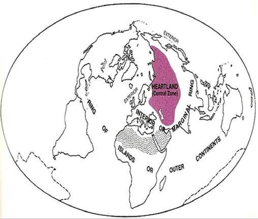
Thus, geopolitics officially appeared as an academic discipline roughly two hundred years ago, in a politically unstable period of history, during which the exploration of the earth had been completed and the major (colonial) powers focused on searching for new methods of increasing their power and establishing their dominion. As a consequence, concepts such as war, secret diplomacy and imperialism, are interrelated with geopolitics (Flint, 2006: 13). During the second half of the 19th century two important geopolitical theories were developed; these approaches appear to be contradictory at first sight, but in essence they are complementary to each other. The first influential idea was put forward by the British geographer Sir Harford Mackinder, who emphasized the control of 'Heartland' (see Figure 1) as an interim step towards world dominance (Mackinder, 1902(Mackinder, , 1904)). Source: Chaliand, G. and Rageau, J. P. (1985) Strategic Atlas, Harmondsworth: Penguin Books, p.21.
Figure1 : Mackinder's' Heartland'
The specific term was conceived in order to describe vast land masses of Europe and Asia (Eurasia), which are protected from the glaciers of the Arctic North. One of their most significant characteristic is that they have easy access to the sea and overlook canals and important straits (maritime traffic chokepoints). Subsequently, he suggested that if a state (or a confederation/bloc of states) manages to control that specific area (continental power) the way to world domination is open. History testifies that two great powers have attempted to dominate over the aforementioned geographical area: Russia and Germany. According to Mackinder, Russia, already very close to the epicenter (heart) of three different continents (Europe-Asia 3 and Africa) is covering many prerequisites; in case it expands its sphere of influence to the 'warm' coasts of Eurasia (Petersen, 2008: 59), then the combination of its huge resources and free access to major trade routes will make the prospective of a global empire visible 4 . Central European territories, as well as the countries around the Baltic and the Black Sea constitute a very vital region, which offers the possibility to the continental power that has control over them to both avert every inimical action coming from the sea and to profit by all the routes of land transport (i.e. rail) in a way that surpasses all the competitive advantages that maritime transport offers. Indeed, Mackinder's best-known saying is the following: 'The 3 A certain number of geopolitical analysts hold the opinion that a substantial distinction between the continents of Europe and Asia does not exist and that these continents should be regarded as an indivisible entity under the name Eurasia. 4 A certain number of geopolitical analysts hold the opinion that a substantial distinction between the continents of Europe and Asia does not exist and that these continents should be regarded as an indivisible entity under the name Eurasia. one that governs Eastern Europe prevails over the Heartland.The one that governs the Heartland prevails over the Global Island.The one that governs the Global Island prevails upon the globe' (Mackinder, 1962: 150), (Chaliand and Rageau, 1985: 20-25).
The second theory under discussion was expounded by the American naval officer Alfred Thayer Mahan, who delved into how Great Britain utilized in a variety of ways its fleet to become dominant in the international system of the 16th-17th century era (Mahan, 1890). Mahan put forward the idea that '?he nation which will dominate the seas shall control the whole world'. His theory is very simple in its conception, since he focused mainly on the fact that maritime power is the 'servant of expansion', since control of the oceans and the seas provides with the opportunity to deliver passengers and goods more easily and economically than all means of transport moving on land. Mahan is the greatest theoretician on maritime power. According to his dogma, no country can be regarded as a global power if its navy is not potent and sufficient enough to promote its power and presence all over the world. At the same time, Mahan underlined the fact that the objective of naval power should be the control of maritime routes, which is achieved by a vast number of large and mighty warships which circulate all over the globe.
Even today, the aforementioned models of how states should behave in order to become a global player strongly influence international relations, as well as the lives of ordinary people. To sum up, according to the predictions of these theories, the access to warm seas, with the long-term objective of global dominion is a diachronic aspiration of any great continental power. Thus, it is obvious why in the past both Kaiser and Hitler followed a similar policy as leaders of Germany, the other contestant (besides Russia) for the trophy of great continental power. And even the USA is moving towards the same direction today, aspiring at securing the entrainment, or else, the encirclement of the heartland, since it is unlikely to conquer it. It is interesting to note that during the Cold War, conflicts between the great powers of that era -USA and USSR-around the Eastern Med were mainly related to a specific strategic objective that as already discussed would pave the way towards global dominance. More specific, the USSR numerous times tried to secure 'access to the warm seas' and the USA concentrated upon avoiding that, in the terms of forming alliances (i.e. both Greece and Turkey jointed NATO) or even resorting into proxy wars.
It is also obvious that similar (low-level) confrontations between the USA and Russia (being the successor of USSR in global politics) have taken place in more recent times. For instance, the Russian attempt to construct an oil-pipeline from Burgas (Bulgaria) to Alexandroupolis (Greece) that would deliver oil from the Black Sea into a Mediterranean port without the use of the Bosporus-Dardanelles straits should be viewed under the framework of the easy access for Russia to warm seas (Dalaklis, Siousiouras and Karkazis, 2008). It is important to point out that the emerging failure of the aforementioned project will probably result in a more aggressive Russian attitude towards other energy transport infrastructures, i.e. natural gas pipelines. Certainly, the pipelines' confrontation will be in the epicenter of Southeastern Europe's politics for the years to come since it enables many geopolitical complexities with wide impact. This is evident through the Russian support for South Stream, a pipeline for the implementation of the southern natural gas supply itinerary of Western and Central Europe 5 , as well as the recent events of the de facto annexation of the Crimea, which, among other expediencies, suggest that Russia wants to be less dependent on Ukraine -a former Russian satellite state that gradually turns on a western oriented country (Desipris, 2011).
In any case, it is clear that with the collapse of the socialist block and the advent of globalization, the role of the Eastern Med in international politics has become more multidimensional. More specifically, during the current period of time, apart from the various geostrategic objectives, which are intensely manifested in events such as the change of regimes in Libyamarked by Gaddafi's execution without a trial-and in Egypt, in the context of the social phenomenon also known as the Arabic Spring, or in the continued up till now civil war in Syria, the expanded area of the Eastern Mediterranean has also have an increased importance in issues of possession-exploitation of very large deposits of energy resources. All the afore mentioned conflicts should be viewed as a different expression of the notorious 'Eastern Question' (the dissolvent of the Ottoman Empire), as the specific issue has not been finally retained yet, although it drastically influenced the history of the Balkan Peninsula and the Mediterranean Sea during the past two centuries 6 .
2. II.
3. The Southeastern Med Basin's Geopolitical Value Nowadays
Recently, according to the data of a United States Geological Service (USGS) study, great deposits of natural gas and petroleum have been discovered in the bed of the Levantine Basin, (which is environed by Cyprus, Israel, the strip of Gaza, Lebanon and Syria). Companies which serve American-Israeli and Norwegian interests have already been granted the permission to research the sea area between Cyprus and Israel and they have announced their discovery of large natural gas deposits. Political events and decisions in the wider region are decisively influenced by the discoveries of new energy resources of carbohydrates in the sea bed between Cyprus and Israel, as well as in the area of the triangle formulated by the (Greek inhabited) islands of Crete-Kastellorizo-Cyprus 7 . The greatest deposits of natural gas seem to exist in the common boundaries of the Exclusive Economic Zones (EEZs) between Cyprus and Israel promising an alternative more stable corridor for the energy sufficiency of the EU in the latter's effort to reduce the dependency from Moscow. . However, not all the EEZs between the neighboring states have yet been determined (except for the zones between Cyprus and Israel, Cyprus and Egypt, Cyprus and Lebanon), even though intensive consultations among the interested parts have commenced for the delimitation of these zones. It should be noted that there are major disputes regarding the issues of the territorial waters and the EEZs (e.g. between Lebanon and Israel, or Israel and the Palestinians in Gaza). Additionally, the existence of a significant amount of natural gas deposits is possible not only in the areas between Cyprus and Israel and between Cyprus and Egypt, but also in the sea area in the west of Cyprus, which is, between the islands of Cyprus and Crete. This widespread belief that the surrounding area is very rich in energy resources, cause since 2008 frictions among the key-players.
Having also in mind the consequences of the recent uprisings against the authoritarian regimes in the Middle East and North Africa, such as the imperilment to the energy security of the western world as well as the increase of the price of energy resources, these frictions result in the creation of a confrontational situation of pulsated intensity over time, while at the same time create significant opportunities for some of the stateactors.
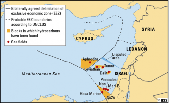
Cyprus, being one of them, took the advantage of the aforementioned geopolitical circumstances and came in 2010 in collaboration with Israel by achieving an agreement on a common exploitation of the adjacent energy deposits 'Leviathan' and 'Venus' (which lie within Block 12 of Cypriot surveys), of the 'Levantine' basin, considering them a unified area of common interest for the two states (see Figure 2 In the aftermath of the abovementioned agreement, there is a diffusive belief that Israel has seriously considered Greece and Cyprus as a transfer node towards Europe of the gas (the so called 'East Med Pipeline') that will be found in its EEZ. That may stand true both because Israel has estimated that the construction of relevant infrastructures could possibly receive financing from Europe and because the alternative route (via Turkey) seems for the moment not to be feasible, on the grounds that Tel-Aviv regards (correctly according to what has been recorded so far) its relatively recent crisis in its relationships with Ankara as not something temporary (Chrysochou and Dalaklis, 2012: 245-263). On the other hand, of course, the option of transferring the Cypriot-Israeli gas to the West via pipeline linked to the Arab Gas Pipeline 8 and through the projection to Turkey seems difficult for the time being because of the increased pipeline security issues due to the volatility in the specific region. Needless to mention, that the option of the cheapest solution, namely the construction of a pipeline from Cyprus to Turkey and then to Western and Central Europe is politically forbidden, at least for the near future, because of the 'Cyprus Question' (Samaras, 2013), (Defencegreece.com, 2012).
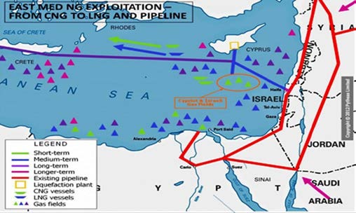
An optimistic perspective of the abovementioned project of the EastMed Pipeline was confirmed by the President of the European Commission during the proceedings of the Council of 22 May 2013, in the general context of determining the future energy priorities of the EU. The energy dependence of the EU by countries belonging to the Arab-Muslim world, which are in a highly sensitive political and geostrategic transition, but also by countries like Russia, which demonstrate a high level of geostrategic competition against the dipole 'Great Britain-USA', forces the Western world, and particularly the EU, to pay attention to the promising hydrocarbon reserves of Cyprus Republic, Israel and Greece. Of course, Israel has not yet decided how to exploit its own deposits, thus what quantities will export to Europe and how will do this -by Liquefied Natural Gas (LNG) or via pipeline or even in a combined way (see Figure 3)., thus via LNG in the short-term and via pipeline in the long term (Dokos, 2012). The type and depth of strategic relationship that Israel will develop with Cyprus, Greece as well as the EU will largely depend on this decision.
Source: Pytheas Ltd.
Figure 3 : The suggestions of transferring the Southeastern Med natural gas to the West However, it is important to note that there are many interested parts meeting in the region, apart from Cyprus, Greece, Turkey and Israel. Except the classical geopolitical pair of USA and Russia, the factor of the EU should also be taken under serious consideration. In addition, the Southeastern Med energy deposits implicate, except the aforementioned countries, Lebanon but also Egypt, Syria, NATO, China, UK as well as Asian, Middle Eastern and African natural gas producing countries. They also implicate the world's most important energy companies, both for their aspirations for a piece of the action but also for the imposed threat of the hydrocarbons deposits to their planned projects.
Nevertheless, as mentioned above, it is too early to speak with absolute optimism for a further development of the other energy deposits of the wider region, since a series of interstate agreements concerning the delimitation of the relevant maritime economic zones is required, while at the same time a series of long-term conflicting issues like the so-called Cyprus Question, the Aegean Dispute and the Middle-East Issue, render the possibility of a comprehensive settlement of the maritime zones rather low (Chrysochou, 2011).
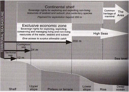
At this point, in order to obtain a thorough view of the parameters taken into account for the delimitation of EEZs of the adjacent states of the wider area of Eastern Med, it is prudent to first set out a brief outline of the relevant theory for the EEZ delimitation and secondly, to depict a comprehensive picture of the maritime delimitation status of the Eastern Med region. Since the aim of the writer is not to induce premature and partial speculations for a 'just' result of EEZ delimitation in the relevant region, this paper, will be limited to a mere depiction of the relevant maritime delimitation situation in Eastern Med. (Oikonomidis, 1985: 182). However, the extension of coastal state jurisdiction in the EEZ limited by 36% the area covered by the open sea accumulating in their favor 95% of world fishery (Karakostanoglou, 1994). Along with the adoption of the EEZ, occurred the problem of its delimitation, given the close linkage of the Continental Shelf and the EEZ. According to UNCLOS article 74 (1), the EEZ delimitation between states with adjacent or opposite coasts, is regulated following an agreement, aiming to achieve a fair solution. In case reaching an agreement is not possible, according to UNCLOS Part XV, the interested parts must resort to conciliation for the settlement of the difference (article 74(2)).
Anyhow, the EEZ delimitation line needs to identify with the corresponding line of the Continental Shelf (see Figure 4), to the degree that the very same sovereign rights in the seabed and the submerged lands of the continental shelf are recognized in favor of the coastal states (Evans, 1989). Self-evidently, despite the obscurity of the clauses concerning the EEZ delimitation, given the overlap of the continental shelf zone and the EEZ, the international application and the corresponding case-law, the clauses on the continental shelf delimitation are applied mutatis mutandis for the provided by UNCLOS for the delimitation of overlapping continental shelves (UNCLOS, 1982: Art. 83), has as a starting (provisional) delimitation line the median line (as a general customary delimitation rule), which is then examined to be modified in the light of the relevant circumstances of the delimitation area, mainly the geographical configuration of the coastline and the proportionality criterion. It is also necessary to point out that the principle of equity as a delimitation method has a technical character, when compared to the median line or to equidistance (Rozakis, 1988: 326).
The above are much more valid in the case of EEZ, to the degree the standard of the distance from the land deadens the corresponding geological standard (natural prolongation) of the Continental Shelf. At this point it is reminded that the Geneva Convention (1958) on the Continental Shelf defines the legal Continental Shelf by emphasizing on the geological standard, an emphasis based on the Truman Declaration influence, particularly for the point it referred to the geological linkage of between the coastal state and the bottom of the sea (Convention on the Continental Shelf, 1958: Art. 1).
On the other hand, UNCLOS by introducing invariable standards for the EEZ and Continental Shelf delimitation (in particular the equidistance standard) limited to a minimum any controversies its estimation could cause (UNCLOS, 1982: Art. 76(1)), while it fortified the equidistance rationale during delimitation (Strati, 2004: 176). In favor of this reasoning it is the fact that the distance standard is the decisive one for the Continental Shelf measurements well until the 200 nm, whereas the geological standard maintains its importance only for the continental- With regard to the Eastern Med, the fact that many states are not signatories to the UNCLOS (Turkey, Israel, etc), combined with the number of maritime delimitations which are required to be settled between countries with contradictory interests and historic rivalries in the wider area, leaves no big room for plotting commonly accepted applicable rules for delimitation purposes. Nevertheless, the Continental Shelf and EEZ boundaries delimitations that have taken place in Eastern Med through agreements and unilateral declarations are the following ones: ? In 1968, Italy and Federal Yugoslavia, delimited by agreement between them their Continental Shelf, and after the collapse of the latter, Croatia announced in 2000 that considers this delimitation boundary to be valid for the EEZ as well, yet in some sections. 9
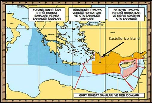
9 Croatia even named this area as an 'Area of Ecological Protection'. However, other adjacent states of the Adriatic Sea which have emerged from the ex-Yugoslavia, namely Montenegro, Slovenia and Bosnia -Herzegovina, assert their participation in the delimitation procedure. However, there's been no result yet, because the last two countries either haven't got any front on the Adriatic Sea or the front they've got is very limited, rendering pending so far a possible settlement of the delimitation boundary. Moreover, there hasn't been yet an official confirmation of the delimitation agreement between Croatia and Montenegro. Finally, in 2005, Slovenia unilaterally defined the coordinates of a specific but temporary as stated area in the .This bilateral agreement between Cyprus and Egypt entered into force on 7 March 2004 (Strati, 2004: 145-209). A fact of particular importance was that the approach taken in determining the westernmost point of the median line between Cyprus and Egypt. On the advice of Greece, citing reasons of avoiding tension with Turkey, the set point of EEZ between Cyprus and Egypt was shifted about 15 to 20 km east of its actual location, so as to keep a potential Greek-Turkish issue of awarding or not a delimitation effect to the Greek island of Kastellorizo temporarily neutral and out of the context of the actual agreement (Kassinis, 2012: 72). The different approaches between Greece and Turkey, concerning maritime delimitation of the Continental Shelf and EEZs in Southeastern Mediterranean, are depicted on Figures 5 and 6.
Adriatic region, while naming that region as an 'Area of Ecological Protection', until the settlement of the Continental Shelf between her and Croatia. 10 Until 2013 France had only declared an EEZ for its western coastal side in the Atlantic Ocean. 11 Article 1(a) of the agreement provides that 'The delimitation of the exclusive economic zone between the two Parties is effected by the median line of which every point is equidistant from the nearest point on the baseline of the two Parties'.
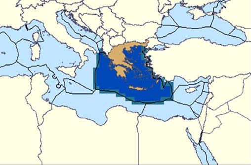
Source: Sea Around Us Project Taking into account that the concept of the Continental Shelf is closely connected to the one of the Exclusive Economic Zone (EEZ), with the latter referring to a littoral state's control over fishery and other similar rights 12 and as it derives from the above figures, Greece supports that the delimitation of the respective zones (both Continental Shelf and EEZ) must be done on the basis of equidistance / median line, asserting full-effect to the southeastern Greek islands of the Aegeanincluding Kastellorizo island. On the other hand, Turkey 12 Both concepts were developed in the context of international law from the middle of the 20th century, and were codified in the United Nations Convention on the Law of the Sea (UNCLOS) in 1982.
Moreover, the ICJ in its judgment in the Libya-Malta Continental Shelf Case asserted that '?the two institutions-continental shelf and exclusive economic zone-are linked together in modern law. Since the rights enjoyed by a state over its continental shelf would also include the seabed and subsoil of any exclusive economic zone which it might proclaim, one of the relevant circumstances to be taken into account for the delimitation of the continental shelf is the legally permissible extent of the exclusive economic zone appertaining to that same state'. seems arguably to support that there is a reduced delimitation effect to those particular islands due to its assertion for the handling of the relevant area as an area of special legal status that justifies the use of equity principles. In this context, Greece claims that all islands must be taken into account on an equal basis for a full effect when it comes to maritime economic zones In this matter, Greece claims to have the UNCLOS on its side, since UNCLOS provides that islands (with the exception of 'rocks') have the right to generate all the maritime zones recognized under international law regardless of their size (UNCLOS, 1982: Art. 121(3)). On the contrary, Turkey argues that the notion of the Continental Shelf, by its very definition, implies that distances should be measured from the continental mainland, meaning that the sea-bed of the Aegean geographically forms a natural prolongation of the Anatolian land mass. 13 In the same context, according to the Turkish aspect the delimitation of the EEZs in the Eastern Mediterranean should follow the principle of natural prolongation, thus not awarding any EEZ effect or CS effect to the islands of the Eastern Aegean and especially to the Dodecanesian small island of Kastellorizo, which is vital for the Greek national interests, as its influence, if recognized, can connect the Hellenic EEZ to the Cypriot EEZ (Chrysochou and Siousiouras, 2013: 112), (Siousiouras, Chrysochou, 2014: 12-49).
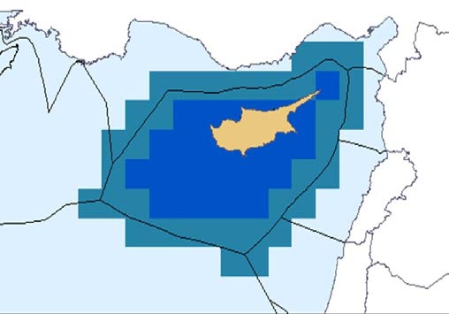
? A similar agreement with Egypt was reached between Cyprus and Lebanon in 2007 (see Figure 7), following a decision by Cyprus to undertake in 2007 the initiation of the first licensing round for hydrocarbon exploration activities and the resulting pursuit of reaching EEZ's agreements with other neighboring countries. The delimitation has been done by agreement on the basis of equidistance / median line on the same content and procedure followed in the respective agreement between Cyprus and Egypt. However, the prolonged instability that prevailed in Lebanon's political scene together with border disputes with Israel, were the main reasons why the ratification of the agreement by the Parliament of Lebanon has not been possible to date (Kassinis, 2012: 77-78). The border dispute between Lebanon and Israel concerns an area of 850 sq.km. Nevertheless, in the margin of an official visit to Cyprus in 2012, the President of the Parliament of Lebanon expressed the intention of the Lebanese Government to sign the agreement immediately after the border settlement with Israel (Press General Secretariat of Cyprus Republic, 2012: 3). ? Finally, on 17 December 2010, the sign of the EEZs' delimitation agreement between the Republic of Cyprus and Israel (see Figure 7) was taken place, based on the delimitation method mentioned above in the already existing agreements with Egypt and Lebanon. This agreement was ratified by the relevant law of the House of Representatives of Cyprus on February 2011. Israel, being a noncontracting party to UNCLOS, and, therefore, not contractually bound by its provisions -except those which constitute rules of customary international law, and only if they are not in conflict with the rules of Israeli domestic law -should have adopted a relevant domestic law as a basic condition for the initiation of official negotiations before concluding an EEZ delimitation agreement with another country. That kind of law was adopted in mid-2010 (Kassinis, 2012: 81-82). ? Referring to the possibility of delimitation of the EEZs between Greece and Cyprus, there hasn't been any agreement so far, despite the insistence by the side of Cyprus Republic. However, the length of the maritime border between the two countries is estimated at 27 nm approximately (Strati, 2012: 150).
Source: Sea Around Us Project. In addition to the abovementioned agreements of maritime delimitation as well as unilateral declarations of EEZs in the Mediterranean region, there are also two maritime delimitation decisions by the ICJ for the cases of Continental Shelves of Tunisia-Libya and Libya-Malta (ICJ, 1982, Judgment, Reports) 14 ,(ICJ, 1985, Judgment, Reports). Moreover, lately, there's a growing desire on 14 Libya has not ratified yet the UNCLOS, remaining though over time committed to the principles of equity / relevant circumstances for the delimitation of maritime zones. In the cases of the delimitation of Continental Shelf boundary with Tunisia in 1982 and Malta in 1985, Libya claimed respectively that the islands have no effect at all in the determination of delimitation line and that the Continental Shelf behalf of the Greek side to start negotiations with the Libyan side in order to reach agreement on maritime delimitation. 15 However, according to the Libyan side, these issues will need to be addressed within a framework which will include third countries with common maritime borders, namely Turkey and Egypt (Hellenic Ministry of Foreign Affairs, 2012).
Over and above, it should be made clear that the non-declaration of EEZ by any coastal state in the region is not a factor that reduces its full sovereign rights in the seabed and subsoil, which are fully guaranteed by the legal regime of the Continental Shelf. Given that the EEZ is -if the coastal State wishes -the possible extension of its sovereign rights at the overlying bottom water column, aiming to control fishery and energy production, in accordance with Article 56 of UNCLOS, the sovereign rights over the Continental Shelf exist for a coastal state ab initio and ipso facto, regardless of any express proclamation (UNCLOS, 1982: Art. 77).
4. IV.
5. Conclusive Remarks
The abovementioned analysis examined the new geopolitical aspect of the Mediterranean Sea, and, particularly what is currently happening in the Southeastern Med basin, namely the geopolitical implications of the recent discoveries of significant energy reserves in that region. The discovered hydrocarbon reserves of the Southeastern Med can and should play an important role in supplying the EU with natural gas in the long run. It comes up, therefore, that any decisions must be taken immediately in order to ensure the primacy of the neighboring states of Eastern Med, especially Cyprus, Israel, Greece and Turkey, regarding their role as alternative suppliers of the European Union. This prospect, with the expected future outcome of providing the first non-Russian gas of the so-called southern European energy corridor, imposes considerable benefits, particularly in relation to potential European funding for a pipeline construction (Eastern Med Pipeline), which will transfer to Central and Western Europe large amounts of natural gas, as well as other relevant projects.
However, linked to the geopolitical dimension there is one more essential parameter; that of International Law of the Sea. UNCLOS provides the necessary framework to define the limits of maritime boundary should not be determined under the principle of equidistance / median line sought by Malta. Moreover, in the latter case Libya asserted as relevant circumstances to be taken into account by the Court, the geomorphologic criteria and the principle of proportionality between the length of the coastline of each state and the respective allocated Continental Shelf areas. 15 Consequently, there have been some contacts at the level of competent experts from the two countries, but also at the level of Foreign Ministers during a meeting held in Tripoli on 21 December 2012. The outcome of that meeting was the agreement between the two sides on a roadmap for issues relating to maritime zones. boundaries between adjacent states, being the main document of international law, which regulates the various issues concerning the establishment of ???. For the moment the question of delimitation of maritime zone boundaries in Southeastern Med remains a point of friction for many of the states involved in. The abovementioned analysis highlighted, inter alia, the decisions made from the Republic of Cyprus and their conformity with international law provisions. Now, it is the turn of the Greek government to take decisive action upon the question of the EEZ in full conformity with international law and in trusting cooperation with its neighboring states, since there are many interested parts meeting in the region, as well as other important protagonists of the international arena with NATO and EU standing out.
In summary, as it is obviously derives from the analysis given in the text, the presence of energy resources in the sea-bed of the Southeastern Med, combined with maritime delimitation issues among the adjacent states, complicates further the geopolitical equation of the region. That's why this particular part of the world constitutes justifiably a perfect case-study of a combined examination of Geopolitics and International Maritime Delimitation Law scientific fields.
V.

| 11 |